Serra Devassa trail
The Serra Devassa is a potuguese sierra located in the parrish of Sete Cidades and is part of the Protected Landscape Area of the Sete Cidades .
The Serra Devassa geological accident has its highest point called the Pico das Mares at 873 meters altitude above the sea level and it also forms one of the largest mountain ranges of the island of Sao Miguel.
This mountainous formation is the craddle of the Western part of the island and home to a large area of forests with rare floral species.
Description of the Serra Devassa trail
Category: Circular
Difficulty: Easy
Distance: 6 KM
Medium time: 2 h
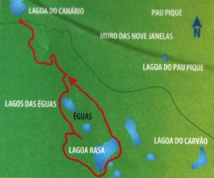
The small circular route of the Serra Devassa trail starts and ends on the Lagoa do Canario and lasts a total of about 2 hours.
The route begins gently rising, bordering a small marshy area and then rises more steeply to reach a geodetic landmark, which marks the highest point of the track. Along this climb you can see to your left, the Wall of Nine Windows (Muro das Nove Janelas), an ancient aqueduct that carried water to Ponta Delgada and Lagoa do Pau Pique which is located in the center of a small volcanic cone.
Nearing the end of the climb, you can see the Lagoa do Eguas on the left and a small circular lagoon on the right. A little ahead you will find a small detour to a lookout where you can see the two lakes mentioned before to the left, and the Lagoa Rasa to the right.
Then the path descends to the edge of Lagoa Rasa, which marks the halfway point of the route. If you go ahead, skirting the lagoon, soon, you go into the cedar wood that will take you back to the beginning of the route point.
Availability:
From Monday to Friday from 9:00 am to 1:30 pm
During the weekend from 9:30 to 2:00 pm
Included in the price: Hotel Pick up e Drop-off, Insurances, Snack’s, Water
Not included in the price: Lunch, Transfer by car/van
Important information: Do not forget to mention the name of your hotel and your room number. The children must be accompanied by an adult.
This Azores Hiking Trail takes place in a zone of altitudes ranging from 750 m to 900 m, so it is advisable to be visited in sunny days, when there is good visibility.